Shortly after clearing the lock we started to hear chatter from other boaters on the VHF that the storm “Ida” was intensifying and that it was headed into the Gulf. Gerry checked all the weather sources we had and confirmed that this was the case. Hummm …. not particularly good news. We’d have to find a good place to hunker down as there was no way we could beat it and get to Mobile Bay and into a marina. We had originally planned on anchoring at the Alabama River Cut Off and, after checking all our resources on board, decided that would still probably be the best place. However, we decided to check with one resource not on board. That was the boat’s previous owner Bill. Gerry gave Bill a quick call and asked for his recommendation. After checking charts, websites, etc. Bill also felt Alabama River Cut Off was the best option. So we continued downriver to our “hurricane hole”. We arrived at the cut off just before 2:00. We slowly motored up the cut around a couple of bends until we reached a spot that allowed us to get out of most of what current there was. We set both bow and stern anchors and settled in. We figured we could do the rest of the lines (tied to trees) early in the morning.
We took the dinghy down and went exploring the area to see if anyone else was around. We found no one else except a fishing boat that had come from one of the camps up river at Bates Lake. On board were a grandfather, grandmother, son, and grandson fishing for catfish. We chatted with them a while and watched as they pulled in the lines. Later, after they had checked all their lines, they dropped by the boat for awhile and suggested that, if the weather got really bad, we were welcome to come up the lake and take refuge at one of the cabins in the area.
We were surprised we got good TV reception here …. Guess we’re not really in the middle of nowhere. We had dinner, watched a little TV and then off to bed thinking about what we’d have to do in the morning to prepare for IDA.
 We woke to a beautiful sunrise. This is looking out to the river from our anchorage.

On our way to the lock, we went by Bobby's Fish Camp. This is a marina (of sorts). It really is just a fuel dock that has a floating dock attached to it where you can tie up. No water or electric, plus they charge you. We chose not to stay there, but instead anchored just a few miles upriver. By the time we passed by, it was empty as all the boats were already at or on their way to the Coffeeville Lock.

Lock gate closing on our last lock for quite some time. After 143 locks, can't say we'll miss locking ... especially on the locks used by commerical traffic.
 A shot looking forward at some of our locking mates.
 A couple of sailboats departing the lock.
 Looking back at the lock and dam
 We noticed a change in the sky. We'd had blue skies for over a week and this morning we had some clouds. Could this be a change in the weather??? (little did we know)
 One of the many sandy beaches along the shoreline
 It may appear that Gerry is just relaxing. However, he is actually working very hard .... at deflating the round fenders. We won't need them again for quite some time, so to save storage space, we take the air out and press them flat .... well as flat as they'll go.
 ..... and here's Gerry with 4 of the deflated fenders .... looking for a place to put them
 We've seen limestone bluffs, dirt bluffs and here's a sand bluff
 We went by a lumberyard where they were spraying the logs with water (you might be able to make out the sprinklers if you enlarge the picture). Gerry figured they dampened down the logs for the same reason they dampened hay in Montana ..... to eliminate the threat of spontaneous combustion.
 Along this part of the waterway, you are in Alabama flat country and trees grow right along the shoreline.
 We approached a railroad bridge and snapped a shot as we went underneath
 Next we passed a steam generating plant
 ... and beside it a crane loading coal from a barge
 This high pile of sand was put here by the Corps of Engineers. They were trying to control the course the river took in this area. The river breached the first dike, so they built this one.
  Arriving at our anchorage, we saw many moss-covered trees
 Here's the spot we choose for our anchorage. Close to the shoreline in a little indentation so we were out of the current.
 While out on our dinghy ride, we met a family that was out catfishing. They have lines tied to many of the low branches. Here they are baiting one of the lines.
 .... and here they are pulling in the lines to see if there are any fish. The little boy was quite the cutie.
 Coming back, you could just barely make out Monk's Vineyard at anchor (sort of in the middle of the picture)
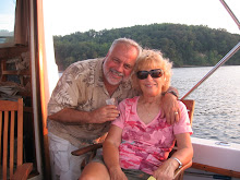
 ... and here's a closer picture. Notice anything different about her. She no longer looks like a Christmas tree as the orange and white balls are gone.
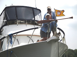
2 comments:
Note to Gerry,
Logs are sprayed with water to keep them from drying out and cracking before being processed. Thought inquiring minds would like to know.
Don
on Moonstruck
Don,
Thanks for the clarification.
When do you guys plan to be down in Boca Grande?
Post a Comment