Saturday, May 28, 2011

Oriental, NC for a Week

5/22 – 5/28 – We decided to stay in Oriental for a week at the Whittaker Point Marina. We stayed here last year as we were finishing up the Great Loop and really enjoyed it. They have a great rate, especially for MTOA members, a beautiful clubhouse with spotless showers and laundry facilities. They also have a courtesy car. We were the only transients at the marina and so the car was pretty much ours whenever we wanted it and for as long as we wanted it. We used it every day, and a couple of times drove into New Bern where we have a townhouse (currently rented).

While at the marina we cleaned the boat up which included “dejunking”, waxing, polishing stainless, cleaning eisen glass and a bunch of other small stuff too numerous to mention. It was looking pretty ragged after its winter in the Bahamas. As our treat for working so hard, we ate out almost every night. For a small town, Oriental has some great restaurants.

We got a big bunch of mail forwarded to us at the marina.  That usually takes several hours to go through.  There's always a few surprises when you get mail in one big shipment that's been accumulating over the past month or two.  Oops, boat insurance due in 5 days.  Now you think we would have remembered that since we're on the boat -- nope, totally slipped our minds.  Linda has an excuse - she's getting old.  In this bunch of mail she got her "welcome to Medicare" package.  Holy crap!*#!#*! -- been declared old by the Federal Government.

Since this is a marina where you buy the boat slip, most of the other folks were only around on the weekend – but with this being a holiday weekend, many arrived early. We got to know our neighbors quite well. Weather permitting, we’ll be heading further north on Sunday. It was a great stay, but it’s time to move on.

View from Whittaker Marina -- our boat is
right in the center of the picture

Nice porch, rockers and view

View during an early morning walk

We had great food (twice) at this unique restaurant
named -- appropriately -- Silos

Cheers !!

Typical view from the club house

Pelicans at the dock

Clubhouse at dusk -- notice the port and starboard lights


Cape Lookout - A Great Stop

Continuing with our quest to visit places we’ve not seen before, we decided to spend a couple of days at Cape Lookout National Seashore. It is a 56 mile section of North Carolina’s Southern Outer Banks. It is comprised of 3 barrier islands, along with Portsmouth Historic Village and Cape Lookout Light. The islands are not commercialized at all – not even any place to leave garbage – you must take it out with you. One of the islands (Shackelford) has wild horses. There are numerous beaches with lots of shelling and a variety of birds and other wildlife. Linda got Gerry to walk the beaches four times in the two days we were there – probably a record. Although it is not known as a seaglass beach, Linda did find one good amethyst piece. Our two days were very peaceful with beautiful sunrises, beach combing, bird and turtle watching, capped off with gorgeous sunsets. This is definitely a place we would revisit.
Arriving at Cape Lookout - we worked our way through all
the fishing boats and entered into the protected cove of Lookout Bight
Our anchorage -- a little threatening the first night,
but nothing materialized
We had a great view of the lighthouse -- here's
the light flashing at night
Morning at the beach - the dinghy with Monk's Vineyard
in the background

A couple of American Oyster Catchers

Sea birds in the sea grass
These are Eastern Willets (I think)

A pair of Laughing Gulls

Cape Lookout Light

Another shot of the lighthouse as we
walked by it

Gerry - just hangin'

Birds doing a flyby

At sunset

Sun sinking fast

New day -- this is just before sunrise

Here comes the sun

Boats aground -- people anchor their boats at
the beach and then set up camp on the beach overnight. 
In the morning they have to wait for the tide to come
in before they can leave

Lots of shelling on the beach - starfish 1

Starfish 2

.. and starfish 3

Now a couple of shots of the beach
As the tide went out it left little pools of water and lots of shells

This is our electronic chart showing where we were.
Shackleford, Harkers and the Core Banks,
along with the area where we were
(a little north of Catfish Point in Lookout Bight)
make up the Cape Lookout National Seashore


Monday, May 23, 2011

Straight Runs

Our journey over the next 2 days might be what you’d call “straight runs”. This is truly a ditch portion of the ICW. Quite narrow and very straight – not much exciting to speak of. The first night we stopped at Wrightville Beach. We’ve stopped here every time we’ve passed through. We dinghied ashore, walked to the beach, then walked the other direction a mile or two down to the ICW and the Wrightsville Beach Bridge. We stopped at a bar/restaurant and had a drink or two before heading back. We had a quiet night and turned in early.

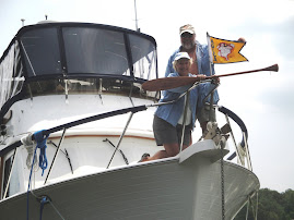
The next morning we timed our departure to make the 8:00 opening of the bridge. We had another bridge (Figure Eight Island Bridge) shortly thereafter, but were able to sneak under without an opening. Good thing, as the bridge was having some repairs and was closed for awhile. The next bridge was the Surf City Bridge which definitely required an opening as it only has a 12 foot clearance. It opens only on the hour, so we tried to time our arrival such that we wouldn’t have to maneuver around waiting for it to open. However, the current was with us this morning and we went way faster than normal arriving about ½ hour before opening. There were osprey all along the way, so we slowed down and watched their antics while we waited (see pictures below).

We had planned on stopping at Mile Hammock Bay to anchor, but we arrived there early in the afternoon, so pressed on. We checked the guidebooks and Active Captain and decided on an anchorage at Swansboro. However, when we arrived it was quite windy plus a lot of current and we really didn’t feel comfortable with the anchorage. We called one of the marinas in the area and got dockage for the night. Ended up staying at Dudley Marina where the rate was only 75 cents a foot – almost like free. Bob and Gayle, friends on Chateau de Mer, pulled in shortly after and docked beside us.

The marina was definitely “homey”. Docks were not the greatest, but the staff was very friendly and helpful. The big draw in this area is the fishing, so the marina store had tons of fishing gear. Gerry looked a lot, but inasmuch as he doesn’t have a license he didn’t buy anything. The food selection at the store was a bit weird. They had ice cream, candy bars, beanie weenies and Vienna sausages.

We spent a quiet night (except for a few wakes from fishing boats) and headed out early the next morning.

Departing Bald Head Island Marina -- that's Old Baldy you see
peaking through towards the left
Passing by the Carolina Beach area
Wrightsville Beach - a bit crowded - guess we've been
spoiled by the beaches in the Bahamas
Wrightsville Beach anchorage at dusk
Starting out the next morning, the water was dead calm
Interesting yard art along
this stretch -- here's King Neptune
 ... A giraffe
... and of course, the pink house.  I wasn't
going to take a picture this time,
but I just couldn't stop
myself 
Mama Osprey seemed to be
in a bit of a huff -- think she
was waiting for "hubby" to bring
back some building material
Oh good -- here he is now with more sticks
That last twig fit just perfect --
I'm quite comfy now
Finally, the Surf City Bridge opened and we were able to pass through
Around mid-day, Winndecks, the Loopers we
met at Myrtle Beach and again at Bald Head
gave us a slow pass, but then "left us in their dust"
as they cruise about 3 times faster than we do.

Saturday, May 21, 2011

Bald Head Island, a Place to Kick Back and Relax

5/16-5/17 - Bald Head Island sits on the northeastern shore at the mouth of the Cape Fear River’s inlet to the ocean. It is accessible only by water. In spite of a push for major development in the 1960’s (which was somewhat thwarted) it has retained much of its unspoiled beaches, marshland and interior forests. There are many expansive home sites, cottages and condos, but they seem to blend in well with their natural surroundings. The streets are narrow and the mode of transportation is by electric golf cart. The marina was nice, but susceptible to quite a surge from the ocean inlet. As luck would have it, the dockmaster had mistakenly assigned us to a slip at the far end of the marina where the surge was not as bad. This area had smaller docks, but we were able to get in okay and tie off the bow of the boat along the short dock and the stern to the pilings. We seemed to ride the surge better here than the boats along the longer docks that were closer to the marina’s entrance channel.

We rented a golf cart and explored the island including Old Baldy Lighthouse, many beaches and the nature preserve. As part of our dockage, we were given a $20 coupon to the restaurant by the marina, Ed and Flo’s, so we happily used it for lunch one day. The weather was a little unsettled while we were here, but the only mishap was Linda getting caught in a downpour during a morning walk. All in all, it was a relaxing 2 days.

Entrance to the Bald Head Island Marina
Once checked into the marina, we wasted no time renting a golf cart.
It's the major form of transportation on the Island.
With map in hand, we went exploring.  All of the beaches are
public and there are many beach access points. 
This one had several long tubes extending out into the ocean.
They were geotextile tubes used for island reclamation and
shoreline protection.
We visited Old Baldy (the lighthouse, not Gerry)
Here at the entrance Gerry is looking pretty happy.
That was before the 180 steps he had to climb

This and the next 3 shots are views from the top


The wind and waves picked up at night.
A shot of one of the piers with water washing
through the boards
 
The full moon rising over the Island


Threatening skies in the morning
 
Sun trying to peak through
Linda headed out for a walk (stinkin' weather
won't stop her)
Two houses along the way with dark clouds building overhead
Things were looking pretty threatening by the time I reached
the beach.  Watched a boat heading out (storm hit 5 minutes later
so I doubt they made it across to the ICW before getting blasted
by the wind and rain).
Looking this direction, things didn't seem so bad,
as there was a bit of clear sky

Oh oh, pretty dark clouds --- should I head back????

Too late -- wind and rain came and within seconds,
I was drenched.
A few hours later, it was beautiful -- here we're
exploring the Cape Fear Frying Pan Shoals area.
Sandbars stretch out for 20 miles into the ocean
and have been responsible for frequent shipwrecks,
making it part of the reason for the "Cape Fear" name.

A large part of the Island is a nature preserve

Although this is part of nature, they were kind of creepy --
hundreds of little crabs scurrying everywhere

Interesting trees
Overlooking the marsh
Flowering cactus
Live oak tree with hanging moss
They have bins for oyster shell recycling here on the Island
... and maybe also for a beer bottle or two
We enjoyed lunch at Eb and Flo's overlooking the harbor