We departed the marina around 7:30. We had called the lock and they were in the process of locking through a tug, but said they’d be ready for us in about a half hour. We departed the marina since the lock was only a couple of miles away. There were several other boats that kept calling trying to make the lock through, so it took awhile as we had to wait for a couple of boats. It should be noted that we are no longer on the Tennessee-Tombigbee Waterway. At Demopolis it changes to the Black Warrior-Tombigbee Waterway.
We had a long day planned. There were no marinas and anchorages were quite scarce. The trip down the river was very scenic, but we did pass more tugs/barges than we have on any other day since we’ve been on the rivers. We planned to anchor in Bashi Creek. We arrived at around 3:30. There was another boat in front of us (Heritage) and we had made tentative plans to anchor together. However, when we arrived Heritage was having difficulty getting into the anchorage because of all the debris. It didn’t look good for us to enter and maneuver around all of the logs and other debris in the water as the anchorage was quite small. We decided to anchor right across from the creek, next to a sandy shore. While we were still in the river, we were out of the way of any tugs/barges that came by. Still, it was kind of unnerving, especially at night to be anchored in the river.
After dinner we watched a movie and then off to bed. It had been a long day. We will head out at first light.
 On the road again, after a couple of days in Demopolis
 Arriving at the Demopolis Lock and Dam
 One of our locking mates - a big steal passenger/car ferry
 The dam .... lots of water being released
Linda waiting patiently to lock through
 There is lots of moss hanging from the trees along the riverbank
 Some of the shoreline we saw today
 We passed by a papermill. Downwind you could really "smell" it.
 Trees at the water's edge
We passed under this interesting bridge
 ... and we saw what looked like an overgrown topiary. However, I'm sure it was just ivy growing on trees.
 Look, here's our restaurant ..... oops, that Ezells, not Etzolds
 Another picture of the erosion that occurs because of the great fluctuation in water levels
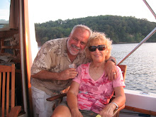
 After being on the boat for 5 months with this grump, Linda had finally had it and told Gerry to go .............
Yup, .... she told him to go fly a kite. In checking through our locker of lines and such to prepare a stern anchor, Gerry found a kite we had on board ... and kids will be kids.
 One of the barges we passed today
 ... and another. This one was very long and the tug had to disconnect from the back of the barge and come up front and push the front around and then go back to the rear and reconnect. The waterday has many, many, many tight turns.

Here are a couple of pictures from the charts showing the course the waterway takes. You can see how it curves around. In one area, if the waterway had been straight, is would have only been a thousand feet from one point to another, but the way it was built, you have to travel 3 miles to get there.
 This is the shoreline where we ended up anchoring.
The river at dusk
 This barge went by after we anchored. Instead of the usual containers or gravel, it had these interesting looking "thinghys". Not sure what they were, but it looked cool going by.
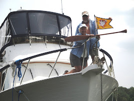
No comments:
Post a Comment